|
Paris wall route stroll right bank Site Home - What's New?-Feedback - About Jack-Travel/Art Links |
![]()
|
Paris through the Ages contents
|
Paris through the Ages-The wall Route, stroll no.4 on the right bank, part 1(all credit to Arthur Gillette) |
|
|
| ...discover PARIS THROUGH THE AGES in the very best way possible :on foot with your own personal guide !!!!! | Rent a wonderful studio in the Marais. Inexpensive and super service. A recommendation | ||
 Let's take again some advice and routing from Arthur Gillette, the American walking tour guide, of which I published already some Marais anecdotes, naughty and bloody.See /Paris/ParisHtml/Paris_Marais_Anecdotes.htm Let's take again some advice and routing from Arthur Gillette, the American walking tour guide, of which I published already some Marais anecdotes, naughty and bloody.See /Paris/ParisHtml/Paris_Marais_Anecdotes.htm He has a lot of tours, assembled in his media-cartes. If Paris main sites have no secrets anymore for you, here is one walk I'm sure you never dreamed of. Of course you must have a bit of interest about history, medieval Paris and let your imagination work a bit. It's stroll no. 4 on the right bank, called "The Wall route". In Arthur's' brochures you have a walking map and pictures included, plus a lot more anecdotes. The tour I resumed from his brochure will develop an overall picture and feeling for the outer limits and general texture of Paris, on both banks. This one goes on the right bank. I suppose you know that Paris was walled from 1200 on by king Philippe Auguste, and that numerous remains are still visible. 5,100 metres long in all, it was between 6 and 9 metres high and tapered slightly upwards from an average width of 2.7 metres at its base. An archer's walkway ran along the top. Why all these defensive measures, when Paris was not especially threatened? First of all, the fear of an invasion by King Richard the Lionheart, who already occupied a good part of today's South-West France, and also Normandy, not far downstream along the Seine, threatening Paris. Second, he wanted Paris protected against his own feudal lords, always fomenting troubles and trying to fight royal power. So the Wall was as psychological as a physical frontier between the rural/feudal power and the urban/bourgeois side, favourable to the king. The Wall clarified things and offered opportunities to the upcoming wealthy bourgeoisie. No wonder that the first rampart was built on the (commercial) right bank between 1190 and 1200. Today the Wall remains here and there along Arthur Gillette's walk, sometimes embedded in buildings above-and below-ground, sometimes in private courtyards. Of course, the walk will take us to those segments visibly publicly, without bothering the inhabitants. It will be done in two parts, plus a few anecdotal facts. But let's start right now; I feel you're getting impatient J. 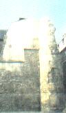 Start at the Jardins Saint Paul (metro Pont Marie). Right across the rue des Jardins Saint-Paul Start at the Jardins Saint Paul (metro Pont Marie). Right across the rue des Jardins Saint-Paul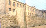 (take a good map with you, or buy the stroll no.4 in English from media-cartes www.media-cartes.fr) here is the first view on the ancient Wall, and the most spectacular length (some 80 metres), extant above ground. Note the impression of raw power exuded by it, which led ever-mocking French writer Rabelais, who lived across the street, to exclaim" By my beard, a cow with a single fart would knock down ten metres of it!" (take a good map with you, or buy the stroll no.4 in English from media-cartes www.media-cartes.fr) here is the first view on the ancient Wall, and the most spectacular length (some 80 metres), extant above ground. Note the impression of raw power exuded by it, which led ever-mocking French writer Rabelais, who lived across the street, to exclaim" By my beard, a cow with a single fart would knock down ten metres of it!" Turn right on rue Charlemagne, then left on rue Saint-Paul, noting at no. 32, the corner of rue Neuve St.Pierre, the Towering remainder of stone work that bore the bells of the medieval St.Paul des Champs church, where royalty was baptised from 1361 to 1559. I have to postpone the suite to my next article, this one being already quite long, but notice we are only at the beginning of this walk. Order Arthur's walking map by mailing to Armedv@aol.com evocating my name : Jack. Bibliography 12th century right bank, "The Wall Route", stroll no.4, English version (ed. Media-Cartes, Paris) |
|||