|
As I said before, the bay cuts 23 km into the land. If, at first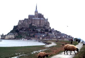 sight, the bay looks very inviting and seems fit for an agreeable promenade, it is very dangerous. The tides are terrible and can be hazardous. The sea mounts sometimes at a speed of 3,7 km an hour (2,5 miles), which is a lot. But at some places the speed of upcoming tide is much quicker, some say, at the speed of a horses gallop (I would say a sight, the bay looks very inviting and seems fit for an agreeable promenade, it is very dangerous. The tides are terrible and can be hazardous. The sea mounts sometimes at a speed of 3,7 km an hour (2,5 miles), which is a lot. But at some places the speed of upcoming tide is much quicker, some say, at the speed of a horses gallop (I would say a 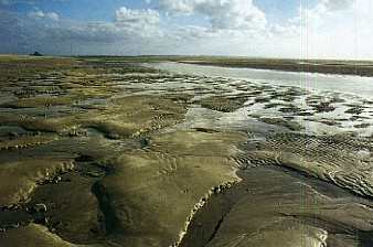 …men’s gallop). I’ve never witnessed such a speed, but some people swear by it. Return to the mainland at least two hours before high tide and take preferable a guide with you. …men’s gallop). I’ve never witnessed such a speed, but some people swear by it. Return to the mainland at least two hours before high tide and take preferable a guide with you.
And there is more: treacherous mists and quick sands serve as natural defenses for the too invading humans. The threat posed by these sands is borne out by Scene 17 of the Bayeux Tapestry, which shows two trapped Norman soldiers being rescued. The mist, mentioned above can fall suddenly in less than an hour and make you lose all sense of direction.
Most people argue that the quick sands are the greatest danger around the Mont. If you know the strands, you can avoid the quick sands, but it is not always easy to spot the deep “water holes”, with aspiring turbulences.
The tides at the Mont are among the highest in the world: 15 meters. Compare it to the tide of Fundy Bay in New Brunswick (Canada), 18 meters!! My readers, who hate these big tides and prefer to taker a dive in, the “Lac Leman”, can be reassured. At some spots the tide doesn’t exceed 20 cm! And it is funny to observe that in New Zealand (exactly the opposite of France on the world map), we have the same phenomenon. Compare it to the tide of Fundy Bay in New Brunswick (Canada), 18 meters!! My readers, who hate these big tides and prefer to taker a dive in, the “Lac Leman”, can be reassured. At some spots the tide doesn’t exceed 20 cm! And it is funny to observe that in New Zealand (exactly the opposite of France on the world map), we have the same phenomenon.
 A great deception, every year, for the Mont Saint Michel visitors, is that they expect the Mont surrounded by water, but all they get to see are parking lots, sand and grass. How come? A great deception, every year, for the Mont Saint Michel visitors, is that they expect the Mont surrounded by water, but all they get to see are parking lots, sand and grass. How come?
Well, the Mont is victim of silting up since several years and you can’t imagine the official panic since a few years to find a solution about that.
But how did it come so far? Let’s get back a few years, end of 19th century. The conjugated action of the sea rivers and particularly the Cuesnon, had immerged a lot of land. Now they wanted to turn these lands into agricultural properties and open at the same time a passage way for the tourists who wanted to visit the Mont. Works are stated, the Cuesnon and rivers are canalised, the See and Selune rivers course is pushed north by the “digue de Roche Torin”. Then the dike connecting the Mont and mainland is built.
All these different works prompted of course a barrage effect and prevented the waters and tides to arrive at full power. The reflux has no power anymore to take back the sand it brought in the first place. And the sea backs up, from year to year, farther and farther.
But hope is the future. Projects are made to cut the dike and replace it by a bridge, giving the sea the opportunity to turn around the Mont and stop the silting up.
Another peril, and a famous one, is the very powerful tourist tide, growing each year!!
That’s why I find it astonishing that among all this fuss and commercialisation, a small community of Benedictine monks still lives and works there. The contrast between their quest for silence, search of spirituality and the noisy and brawling tourists is so enormous, that it is unbelievable. Chased out of the Mont Saint Michel by the French revolution, they returned in 1966. Like the father prior of the abbey said in an interview: “the rule of Saint Benoit imposes us silence. But look at the paradox: 2,500,000 persons a year we have not only to accept, but more, to love….”.
Bibliography
Le Mont-Saint-Michel pierre à pierre by Marc Deceneux (Éditions Ouest France 1996), Millénaire monastique du Mont-Saint-Michel, by Michel Nortier( ed. Lethellieux Paris 1993),Le Mont-Saint-Michel,Histoire (Éditions du patrimoine), L'abbaye du Mont-Saint-Michel (Les grands sites et monuments du monde at Gallimard, Le Mont-Saint-Michel, monastère et citadelle by Lucien Bély (Éditions Ouest France 1996)
|