|
From Nice to Menton
Nice
From Nice to
Menton-an itinerary
Villefranche-sur
mer
Saint-Jean-Cap
Ferrat
Beaulieu-Villa
Kerylos
Eze
perched village
Monaco
La
Turbie
Roquebrune-Cap Saint-Martin
Menton
From Nice to
Saint-Tropez
Cagnes-sur-Mer
Saint Paul de Vence
Vence-Matisse
chapel-City
Tourettes-Gorges
du
Loup-Gourdon
Grasse
Cabris and Valbonne
(anecdotes!)
Biot
Antibes
|
 The
Iles d'Hyeres are in fact 3 islands: Porquerolles, Port-Cros and Ile du Levant. The
Iles d'Hyeres are in fact 3 islands: Porquerolles, Port-Cros and Ile du Levant.
At the place called LA TOUR FONDUE, at the end of the Giens peninsula outside
Hyéres, you can take a ferry to the “Golden Islands” like the Iles d’Hyéres
are also called, and Porquerolles in particular.
La Tour Fondue is a splendid small fort, built on order of the cardinal de
Richelieu, to control the passage to the isles. In front of the fort we have the
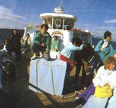
embarkation spot for the speedboat shuttles bringing you in 20 minutes to the
Islands. You have also regular connections during the summer from Toulon, Le
Lavandou, Cavalaire, Bormes. When the wind strength forecast is heavy, no
transports and no visits to the isle. Make your inquiries before you decide to
go.
Notice that there is no regular connection between Port-Cros and Porquerolles.
Since Porquerolles is a haven for bikers, you can take your bicycle on the
boats. Even if you don’t have one, you can rent whatever you like, from a
mountain bike to a regular one, at the hour or for the day.
François I granted the right of asylum to convicts provided they would live on
the islands and
protect them against pirates and corsairs. However, the criminal underclass
flooded the islands and turned into piracy themselves, rewarding the king’s
generosity by trying to capture one of his ships. In
1793 the British landed on Porquerolles and blew up the fort, and in August 1944
American troops landed on the islands of Port-Cros and Le Levant to fight off
German batteries.
Porquerolles, so called because of the wild boar that once roamed there, is the
largest and most important of the islands. It doesn’t have a population of
even 300, living mainly from the tourist industry around their little port. 8 km
long on 2 km wide, it is a paradise for family walks. Cars are very rare and
there are no roads. On the northern coast, superb beaches are sheltered by a
very protected flora. The southern coast where a lighthouse is in operation is
very hilly. Outside July and August you will see nobody on its trails.
It offers the most amenities for families, pleasure craft owners and the less
intrepid while its white sandy beaches and woods of pine heather, eucalyptus and
myrtle remain remarkably unspoilt.
 The
island’s village, also called Porquerolles, has a strong colonial flavour in
the simple style of its houses, since it was meant to be a garrison place in the
19th century, amidst an enormous exercise field. That explain also the cheerless
sand plain in the centre, now agreeable surrounded by restaurants, cafés, shops
and beautiful eucalyptus trees. The strange church on the square is from 1851
and reminds the military, colonial style of France in the 19th century.
Inexpensive lunches can be enjoyed at one of the many restaurants but I don’t
guarantee high-refined cuisine! The
island’s village, also called Porquerolles, has a strong colonial flavour in
the simple style of its houses, since it was meant to be a garrison place in the
19th century, amidst an enormous exercise field. That explain also the cheerless
sand plain in the centre, now agreeable surrounded by restaurants, cafés, shops
and beautiful eucalyptus trees. The strange church on the square is from 1851
and reminds the military, colonial style of France in the 19th century.
Inexpensive lunches can be enjoyed at one of the many restaurants but I don’t
guarantee high-refined cuisine!
Like I said in my introduction, hire mountain bikes or the gearless classique
ones and set off with a picnic to the lighthouse or beaches on the north or
south coast.
Take the little road crossing the cemetery to walk to the lighthouse, Cap
d'Armes and Gorge
du Loup. Count about 1.30 to 2 hours.
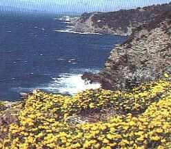
The lighthouse is the most powerful of the Mediterranean after that of Marseille
with a range of 54 km. Climb the lighthouse to enjoy dramatic views of the hills
of the Grand Langoustier to the west, St.Agatha’s fort to the south as well as
the cliffs of the south coast. Impressive Gorge du Loup where the sea clashes
impetuously. Bathing is extremely dangerous and when the mistral blows you can
hardly stand straight up.
Passing along the lagunas you can witness the stunning way the inhabitants deal
with their used domestic waters. They dump their used waters in the lagunas
where the sun, the oxygen, the seaweeds, the bacterias eliminate almost
completely the germs. It is so effective that the water us used again for the
cultures, and seems so clean that is difficult to convince the visitors not to
bath in them!
The Langoustier peninsula is on the east point of Porquerolles. A fort built by
the orders of Richelieu in 1633 dominated the sea from a 24 m height. When the
weather is clear there is an excellent view out across the plains and seaside
and the Plage de Notre-Dame cove, the other islands and the mainland
(about 2 hours out and back). Also the cap Scié at the horizon, 25 km away. A
walk across the island to the lighthouse (phare) is popular, passing through
botanical plantations including fig trees and olive trees. (Panels even show the
variety of each individual olivier.) The area near the lighthouse has good views
of the calanques.
If you only have a short time, we would suggest a walk past the Plage de
la Courtade (or Grande Plage) for an intensive sunbathing are: the
preferred of the sun worshippers, plage 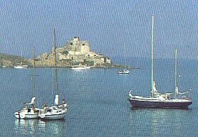 Notre Dame, the largest of the island. To reach it you have a gentle 3 km walk.
One with transparent, well protected and surrounded with trees, is the plage d’Argent,
left of the harbour. Nice silvery sand. The Fort de la Repentance appears
as a low, fortified structure on the hilltop, with (dry) moat all around. In
fact, it's mostly underground inside the hill. It's still an active fort, so no
entry, although it's alright to explore around it. When we passed by, the troops
were barbequing lunch, and the only unfriendliness we encountered were the
attack seagulls when we got too close to their nests with fuzzy young hatchlings
in the nearby rocks. Nearer to us, the Giens peninsula is only separated
by a few small islands, maybe a mile distance.
Notre Dame, the largest of the island. To reach it you have a gentle 3 km walk.
One with transparent, well protected and surrounded with trees, is the plage d’Argent,
left of the harbour. Nice silvery sand. The Fort de la Repentance appears
as a low, fortified structure on the hilltop, with (dry) moat all around. In
fact, it's mostly underground inside the hill. It's still an active fort, so no
entry, although it's alright to explore around it. When we passed by, the troops
were barbequing lunch, and the only unfriendliness we encountered were the
attack seagulls when we got too close to their nests with fuzzy young hatchlings
in the nearby rocks. Nearer to us, the Giens peninsula is only separated
by a few small islands, maybe a mile distance.
Bibliography:
John Pemble, "the Mediterranean Passion, Victorians and Edwardians in the
South", (Oxford University Press 1988), Mary Blume, "Cote d'Azur.
Inventing the French Riviera" (Thames and Hudson, London 1982), The
Twenties, From Notebooks and Diaries of the Period, by Edmund Wilson (Cannes
1921), " Iles en Méditerranée", by Fr.Leclere (JC.Lattes ed.-Paris
1998)
|
From Nice to Saint-Tropez (suite)
Cap
d'Antibes
Juan les
Pins-Golfe-Juan-Vallauris
Cannes
Iles
de Lerins
La
Napoule and Henry Clews
Esterel
cornice to Frejus
Frejus
Sainte Maxime to Port Grimaud
Old Grimaud and Cogolin
Saint-Tropez
From Saint Tropez to Cassis
Ramatuelle-Gassin-Croix
Valmer-Cavalaire
sur mer
Le
Lavandou-Bormes les Mimosas
Hyères
Island of
Porquerolles
Island of Port Cros - Ile du
Levant
Toulon
From Toulon to
Sanary-sur-Mer
Bandol
and island of Bendor
La
Ciotat and route des Cretes
Cassis and the calanques
|